Ukraine
UKR
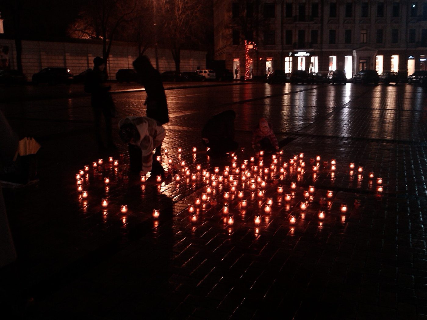
Lamps with candles in the square near Saint Sophia Cathedral in Kiev · Photo: Роман Рябенко /
CC0
via Wikimedia Commons
523
Records
10
Datasets
32
Tables
10
Sources
147
SEL Fields
53
CCL Fields
📋
Most recent national census: 2001.
Not yet carried in HERA —
Ukraine has held a national census; HERA simply doesn't carry it on
this page yet (the source may be access-restricted, PDF-only, or not yet ingested). Its
absence here does not mean no census was taken.
🗺 HERA does carry a modeled subnational
estimate for Ukraine:
UKR-LANDSCAN (2024)
— 27 subnational units
across
admin_1 (27).
Modeled, not enumerated — it is an estimate built on census
inputs, not the published tabulation.
Loading overview…
Disputed territories & how this country's data is framed
HERA reports each party's claim and does not adjudicate. A territory's population is counted once, on one country's roll-up.
- Crimea
—
Claimed here; administered by RUS.
HERA counts it once, on the UKR roll-up (a counting convention).
Administered by Russia since 2014; claimed by Ukraine.HERA counts the territory once, on the Ukraine roll-up, following UN General Assembly Resolution 68/262. That is a counting convention that prevents a double count; it is not a statement by HERA about sovereignty.
Datasets (10)
SEL — DGIWG Statistical Extent Location
SEL+ — Platform extension (not in DGIWG core spec)
CCL — DGIWG Cultural Context Location
Extension — Preserved in extension tables (not in core SEL/CCL schema)
Pending — Not yet mapped to SEL/CCL. The field is still kept in the inventory and the download; nothing is dropped. Reference data that is not census (ports, risk indices) may stay here.
4 further sources (Ethnic Power Relations Dataset, GI-TOC / ENACT, Global Data Lab, World Values Survey) are held but not offered: their licences do not permit commercial redistribution. HERA cites their published findings with attribution and can supply the data to organisations holding their own licence — ask us.
UKR World Bank Open Data
UKR-WORLD_BANK
Development Indicators
or use the per-admin-level buttons below. Free downloads return a 10-row sample.
Contact us for the full pack.
0
Admin 0
— 3 table(s)
UKR World Bank - Development Indicators
— 66 rows, 9 columns
Loading data…
Field details — 9 fields (type, nulls, unique, samples)
Standards-Aligned Fields (7)
| Field Name | Label | Type | Schema | Nulls | Unique | Samples |
|---|---|---|---|---|---|---|
country_code |
Country code | string | SEL | 0% | 1 | UA, UA, UA, UA, UA |
population_count |
Population count | float | SEL | 2% | 65 | 42824093.0, 43399766.0, 43943674.0, 44462372.0, 44951156.0 |
life_expectancy |
Life expectancy | float | SEL | 3% | 64 | 69.388, 70.044, 70.401, 70.683, 70.972 |
gdp_per_capita_usd |
Gdp per capita usd | float | SEL | 42% | 38 | 1244.04125976563, 1444.248046875, 1593.07861328125,... |
literacy_rate_pct |
Literacy rate percent | float | SEL | 99% | 1 | 99.4300003051758 |
under5_mortality_per_1000 |
Under5 mortality per 1000 | float | SEL | 20% | 50 | 32.3, 31.3, 30.4, 29.6, 28.9 |
poverty_headcount_pct |
Poverty headcount percent | float | SEL | 91% | 6 | 51.9, 51.1, 34.9, 27.6, 23.1 |
Extension Fields (2)
— supplemental data preserved outside core SEL/CCL schema
| Field Name | Label | Type | Nulls | Unique | Samples |
|---|---|---|---|---|---|
country_name |
country_name | string | 0% | 1 | Ukraine, Ukraine, Ukraine, Ukraine, Ukraine |
year |
year | integer | 0% | 66 | 1960, 1961, 1962, 1963, 1964 |
UKR World Bank - Health Indicators
— 66 rows, 14 columns
Loading data…
Field details — 14 fields (type, nulls, unique, samples)
Standards-Aligned Fields (12)
| Field Name | Label | Type | Schema | Nulls | Unique | Samples |
|---|---|---|---|---|---|---|
country_code |
Country code | string | SEL | 0% | 1 | UA, UA, UA, UA, UA |
life_expectancy |
Life expectancy | float | SEL | 3% | 64 | 69.388, 70.044, 70.401, 70.683, 70.972 |
infant_mortality_per_1000 |
Infant mortality per 1000 | float | SEL | 39% | 34 | 14.1, 13.5, 13.0, 12.6, 12.2 |
under5_mortality_per_1000 |
Under5 mortality per 1000 | float | SEL | 20% | 50 | 32.3, 31.3, 30.4, 29.6, 28.9 |
maternal_mortality_per_100k |
Maternal mortality per 100k | float | SEL | 41% | 23 | 53.0, 50.0, 46.0, 44.0, 42.0 |
fertility_rate |
Fertility rate | float | SEL | 3% | 62 | 2.285, 2.197, 2.154, 2.111, 2.014 |
birth_rate_per_1000 |
Birth rate per 1000 | float | SEL | 3% | 63 | 20.83, 19.738, 18.906, 18.011, 16.564 |
death_rate_per_1000 |
Death rate per 1000 | float | SEL | 3% | 64 | 8.248, 8.019, 7.94, 7.898, 7.863 |
physicians_per_1000 |
Physicians per 1000 | float | SEL | 46% | 34 | 3.515, 3.631, 3.741, 3.82, 3.909 |
hospital_beds_per_1000 |
Hospital beds per 1000 | float | SEL | 35% | 42 | 12.143500328064, 12.2532997131348, 12.3577995300293,... |
vaccination_rate_pct |
Vaccination rate percent | float | SEL | 50% | 19 | 88.0, 93.0, 97.0, 98.0, 99.0 |
health_expenditure_pct_gdp |
Health expenditure percent gdp | float | SEL | 67% | 22 | 5.30685186, 5.72534418, 5.99220037, 6.54574108, 6.16856956 |
Extension Fields (2)
— supplemental data preserved outside core SEL/CCL schema
| Field Name | Label | Type | Nulls | Unique | Samples |
|---|---|---|---|---|---|
country_name |
country_name | string | 0% | 1 | Ukraine, Ukraine, Ukraine, Ukraine, Ukraine |
year |
year | integer | 0% | 66 | 1960, 1961, 1962, 1963, 1964 |
UKR World Bank - Migration Indicators
— 66 rows, 9 columns
Loading data…
Field details — 9 fields (type, nulls, unique, samples)
Standards-Aligned Fields (1)
| Field Name | Label | Type | Schema | Nulls | Unique | Samples |
|---|---|---|---|---|---|---|
country_code |
country_code | string | SEL | 0% | 1 | UKR, UKR, UKR, UKR, UKR |
Pending (8) — awaiting mapping
| Field Name | Label | Type | Nulls | Unique | Samples |
|---|---|---|---|---|---|
country_name |
country_name | string | 0% | 1 | Ukraine, Ukraine, Ukraine, Ukraine, Ukraine |
year |
year | integer | 0% | 66 | 1960, 1961, 1962, 1963, 1964 |
intl_migrant_stock |
intl_migrant_stock | float | 88% | 8 | 6892920.0, 6172338.0, 5527087.0, 5050302.0, 4818767.0 |
intl_migrant_stock_pct |
intl_migrant_stock_pct | float | 88% | 7 | 13.2, 11.9, 11.2, 10.6, 10.4 |
net_migration |
net_migration | float | 0% | 66 | 52281.0, 51625.0, 45712.0, 60178.0, 76650.0 |
remittances_received_usd |
remittances_received_usd | float | 56% | 28 | 6000000.0, 12000000.0, 12000000.0, 18000000.0, 419000000.0 |
remittances_received_pct_gdp |
remittances_received_pct_gdp | float | 56% | 29 | 0.0134653442755677, 0.0239274846034381,... |
remittances_paid_usd |
remittances_paid_usd | float | 58% | 25 | 1000000.0, 4000000.0, 3000000.0, 3000000.0, 5000000.0 |
UKR LandScan Global (ORNL)
UKR-LANDSCAN
Modeled Population
or use the per-admin-level buttons below. Free downloads return a 10-row sample.
Contact us for the full pack.
0
Admin 0
— 1 table(s)
UKR LandScan - Population Admin0 (admin_0)
— 1 rows, 7 columns
Loading data…
Field details — 7 fields (type, nulls, unique, samples)
Standards-Aligned Fields (7)
| Field Name | Label | Type | Schema | Nulls | Unique | Samples |
|---|---|---|---|---|---|---|
country_code |
Country code | string | SEL | 0% | 1 | UKR |
admin_level |
Admin level | string | SEL | 0% | 1 | admin_0 |
admin_name |
Admin name | string | SEL | 0% | 1 | Ukraine |
admin_code |
Admin code | string | SEL | 0% | 1 | 60985579B58127766181095 |
area_sqkm |
Area sqkm | float | SEL | 0% | 1 | 640028.0993 |
pop_2024 |
Population count | integer | SEL | 0% | 1 | 35660244 |
pop_density_2024 |
Population density | float | SEL | 0% | 1 | 55.72 |
1
Admin 1
— 1 table(s)
UKR LandScan - Population Admin1 (admin_1)
— 27 rows, 7 columns
Loading data…
Field details — 7 fields (type, nulls, unique, samples)
Standards-Aligned Fields (7)
| Field Name | Label | Type | Schema | Nulls | Unique | Samples |
|---|---|---|---|---|---|---|
country_code |
Country code | string | SEL | 0% | 1 | UKR, UKR, UKR, UKR, UKR |
admin_level |
Admin level | string | SEL | 0% | 1 | admin_1, admin_1, admin_1, admin_1, admin_1 |
admin_name |
Admin name | string | SEL | 0% | 27 | Kyiv, Lviv Oblast, Kyiv Oblast, Autonomous Republic of... |
admin_code |
Admin code | string | SEL | 0% | 27 | 14850775B22712718081002, 14850775B26941409899318,... |
area_sqkm |
Area sqkm | float | SEL | 0% | 27 | 825.1594, 21832.2664, 28138.9037, 41684.7189, 31912.45 |
pop_2024 |
Population count | integer | SEL | 0% | 27 | 3201799, 2783980, 2226346, 2099010, 2074402 |
pop_density_2024 |
Population density | float | SEL | 0% | 27 | 3880.22, 127.52, 79.12, 50.35, 65.0 |
Locality
Locality
— 1 table(s)
UKR LandScan - Cities (locality)
— 75 rows, 9 columns
Loading data…
Field details — 9 fields (type, nulls, unique, samples)
Standards-Aligned Fields (7)
| Field Name | Label | Type | Schema | Nulls | Unique | Samples |
|---|---|---|---|---|---|---|
country_code |
Country code | string | SEL | 0% | 1 | UKR, UKR, UKR, UKR, UKR |
admin_level |
Admin level | string | SEL | 0% | 1 | locality, locality, locality, locality, locality |
admin_name |
Admin name | string | SEL | 0% | 75 | Kyiv, Odesa, Lviv, Kharkiv, Dnipro |
admin_code |
Admin code | integer | SEL | 0% | 75 | 2125, 2573, 720, 3811, 3618 |
area_sqkm |
Area sqkm | float | SEL | 0% | 75 | 410.5164, 176.0698, 98.1114, 232.2677, 201.1588 |
pop_2024 |
Population count | integer | SEL | 0% | 75 | 3079812, 741667, 674599, 669448, 486064 |
pop_density_2024 |
Population density | float | SEL | 0% | 75 | 7502.29, 4212.35, 6875.85, 2882.23, 2416.32 |
Extension Fields (2)
— supplemental data preserved outside core SEL/CCL schema
| Field Name | Label | Type | Nulls | Unique | Samples |
|---|---|---|---|---|---|
ghs_pop_2025 |
ghs_pop_2025 | integer | 0% | 75 | 2575199, 977813, 604320, 1284380, 761540 |
landscan_vs_ghs_ratio |
landscan_vs_ghs_ratio | float | 0% | 74 | 1.196, 0.758, 1.116, 0.521, 0.638 |
UKR GHS Urban Centre Database (EU JRC)
UKR-GHSL_UCDB
Modeled Population
or use the per-admin-level buttons below. Free downloads return a 10-row sample.
Contact us for the full pack.
Locality
Locality
— 1 table(s)
UKR GHS-UCDB - Cities (locality)
— 75 rows, 10 columns
Loading data…
Field details — 10 fields (type, nulls, unique, samples)
Standards-Aligned Fields (3)
| Field Name | Label | Type | Schema | Nulls | Unique | Samples |
|---|---|---|---|---|---|---|
city_name |
Admin name | string | SEL | 0% | 75 | Kyiv, Kharkiv, Odesa, Dnipro, Donetsk |
country_code |
Country code | string | SEL | 0% | 1 | UKR, UKR, UKR, UKR, UKR |
population |
Population count | integer | SEL | 0% | 75 | 2575199, 1284380, 977813, 761540, 690522 |
Extension Fields (7)
— supplemental data preserved outside core SEL/CCL schema
| Field Name | Label | Type | Nulls | Unique | Samples |
|---|---|---|---|---|---|
city_id |
city_id | integer | 0% | 75 | 2125, 3811, 2573, 3618, 4383 |
name_alternates |
name_alternates | string | 100% | - | - |
country_name |
country_name | string | 0% | 1 | Ukraine, Ukraine, Ukraine, Ukraine, Ukraine |
population_year |
population_year | integer | 0% | 1 | 2025, 2025, 2025, 2025, 2025 |
latitude |
latitude | string | 100% | - | - |
longitude |
longitude | string | 100% | - | - |
region |
region | string | 100% | - | - |
UKR UNHCR Refugee Data Finder
UKR-UNHCR
Migration
or use the per-admin-level buttons below. Free downloads return a 10-row sample.
Contact us for the full pack.
0
Admin 0
— 2 table(s)
UKR UNHCR - Hosted Populations
— 32 rows, 24 columns
Loading data…
Field details — 24 fields (type, nulls, unique, samples)
Standards-Aligned Fields (6)
| Field Name | Label | Type | Schema | Nulls | Unique | Samples |
|---|---|---|---|---|---|---|
country_of_origin_iso |
Country of origin iso | string | CCL | 0% | 1 | -, -, -, -, - |
refugees |
Refugees | integer | CCL | 0% | 75 | 2116011, 1952928, 1847304, 1749628, 1717966 |
idps |
Idps | integer | CCL | 0% | 34 | 0, 0, 0, 0, 0 |
stateless |
Stateless | integer | CCL | 0% | 23 | 0, 0, 0, 0, 0 |
others_of_concern |
Others of concern | integer | CCL | 0% | 30 | 0, 0, 0, 0, 0 |
total_population |
Total population | string | CCL | 100% | - | - |
Extension Fields (18)
— supplemental data preserved outside core SEL/CCL schema
| Field Name | Label | Type | Nulls | Unique | Samples |
|---|---|---|---|---|---|
year |
year | integer | 0% | 75 | 1951, 1952, 1953, 1954, 1955 |
country_of_origin |
country_of_origin | string | 100% | - | - |
country_of_asylum |
country_of_asylum | string | 100% | - | - |
country_of_asylum_iso |
country_of_asylum_iso | string | 0% | 1 | -, -, -, -, - |
population_type |
population_type | string | 100% | - | - |
asylum_seekers |
asylum_seekers | integer | 0% | 34 | 0, 0, 0, 0, 0 |
female_total |
female_total | string | 100% | - | - |
male_total |
male_total | string | 100% | - | - |
female_0_4 |
female_0_4 | string | 100% | - | - |
female_5_11 |
female_5_11 | string | 100% | - | - |
female_12_17 |
female_12_17 | string | 100% | - | - |
female_18_59 |
female_18_59 | string | 100% | - | - |
female_60_plus |
female_60_plus | string | 100% | - | - |
male_0_4 |
male_0_4 | string | 100% | - | - |
male_5_11 |
male_5_11 | string | 100% | - | - |
male_12_17 |
male_12_17 | string | 100% | - | - |
male_18_59 |
male_18_59 | string | 100% | - | - |
male_60_plus |
male_60_plus | string | 100% | - | - |
UKR UNHCR - Origin Populations
— 34 rows, 24 columns
Loading data…
Field details — 24 fields (type, nulls, unique, samples)
Standards-Aligned Fields (6)
| Field Name | Label | Type | Schema | Nulls | Unique | Samples |
|---|---|---|---|---|---|---|
country_of_origin_iso |
Country of origin iso | string | CCL | 0% | 1 | -, -, -, -, - |
refugees |
Refugees | integer | CCL | 0% | 75 | 2116011, 1952928, 1847304, 1749628, 1717966 |
idps |
Idps | integer | CCL | 0% | 34 | 0, 0, 0, 0, 0 |
stateless |
Stateless | integer | CCL | 0% | 23 | 0, 0, 0, 0, 0 |
others_of_concern |
Others of concern | integer | CCL | 0% | 30 | 0, 0, 0, 0, 0 |
total_population |
Total population | string | CCL | 100% | - | - |
Extension Fields (18)
— supplemental data preserved outside core SEL/CCL schema
| Field Name | Label | Type | Nulls | Unique | Samples |
|---|---|---|---|---|---|
year |
year | integer | 0% | 75 | 1951, 1952, 1953, 1954, 1955 |
country_of_origin |
country_of_origin | string | 100% | - | - |
country_of_asylum |
country_of_asylum | string | 100% | - | - |
country_of_asylum_iso |
country_of_asylum_iso | string | 0% | 1 | -, -, -, -, - |
population_type |
population_type | string | 100% | - | - |
asylum_seekers |
asylum_seekers | integer | 0% | 34 | 0, 0, 0, 0, 0 |
female_total |
female_total | string | 100% | - | - |
male_total |
male_total | string | 100% | - | - |
female_0_4 |
female_0_4 | string | 100% | - | - |
female_5_11 |
female_5_11 | string | 100% | - | - |
female_12_17 |
female_12_17 | string | 100% | - | - |
female_18_59 |
female_18_59 | string | 100% | - | - |
female_60_plus |
female_60_plus | string | 100% | - | - |
male_0_4 |
male_0_4 | string | 100% | - | - |
male_5_11 |
male_5_11 | string | 100% | - | - |
male_12_17 |
male_12_17 | string | 100% | - | - |
male_18_59 |
male_18_59 | string | 100% | - | - |
male_60_plus |
male_60_plus | string | 100% | - | - |
UKR Glottolog Language Catalog
UKR-GLOTTOLOG
Language
or use the per-admin-level buttons below. Free downloads return a 10-row sample.
Contact us for the full pack.
0
Admin 0
— 1 table(s)
UKR Glottolog - Languages
— 32 rows, 16 columns
Loading data…
Field details — 16 fields (type, nulls, unique, samples)
Standards-Aligned Fields (12)
| Field Name | Label | Type | Schema | Nulls | Unique | Samples |
|---|---|---|---|---|---|---|
glottocode |
Glottocode | string | CCL | 0% | 32 | balk1252, bash1264, bela1254, blis1239, bulg1262 |
name |
Name | string | CCL | 0% | 32 | Balkan Romani, Bashkir, Belarusian, Blissymbols, Bulgarian |
iso639_3 |
Iso639 3 | string | CCL | 3% | 31 | rmn, bak, bel, zbl, bul |
level |
Level | string | CCL | 0% | 1 | language, language, language, language, language |
family_name |
Family name | string | CCL | 100% | - | - |
family_glottocode |
Family glottocode | string | CCL | 0% | 6 | indo1319, turk1311, indo1319, arti1236, indo1319 |
parent_name |
Parent name | string | CCL | 100% | - | - |
parent_glottocode |
Parent glottocode | string | CCL | 0% | 25 | roma1329, bash1267, east1426, arti1236, mace1252 |
endangerment_status |
Endangerment status | string | CCL | 100% | - | - |
child_family_count |
Child family count | integer | CCL | 0% | 1 | 0, 0, 0, 0, 0 |
child_language_count |
Child language count | integer | CCL | 0% | 1 | 0, 0, 0, 0, 0 |
child_dialect_count |
Child dialect count | integer | CCL | 0% | 16 | 19, 3, 3, 0, 22 |
Extension Fields (4)
— supplemental data preserved outside core SEL/CCL schema
| Field Name | Label | Type | Nulls | Unique | Samples |
|---|---|---|---|---|---|
latitude |
latitude | float | 3% | 31 | 42.67, 53.59671, 53.2307, 43.3646, 48.1968 |
longitude |
longitude | float | 3% | 31 | 21.17, 56.55937, 25.6038, 25.047, 20.3129 |
country_codes |
Country codes | string | 0% | 27 | ['AL', 'AT', 'BA', 'BG', 'BY', 'CH', 'CZ', 'DE', 'FI',... |
classification |
classification | string | 0% | 1 | [], [], [], [], [] |
UKR NGA World Port Index (Pub 150)
UKR-NGA_WPI
Maritime Ports
26 rows × 112 columns ingested. Field-level inventory in progress —
contact us for the full export.
0
Admin 0
— 1 table(s)
UKR NGA WPI - Ports
— 26 rows, 112 columns
Loading data…
Field details — 112 fields (type, nulls, unique, samples)
Pending (112) — awaiting mapping
| Field Name | Label | Type | Nulls | Unique | Samples |
|---|---|---|---|---|---|
country_code |
country_code | string | 0% | 1 | UKR, UKR, UKR, UKR, UKR |
admin_level |
admin_level | string | 0% | 1 | admin_0, admin_0, admin_0, admin_0, admin_0 |
country_name |
country_name | string | 0% | 1 | Ukraine, Ukraine, Ukraine, Ukraine, Ukraine |
OID_ |
OID_ | integer | 0% | 26 | 1419, 1420, 1421, 1422, 1423 |
World Port Index Number |
World Port Index Number | integer | 0% | 26 | 44010, 44000, 43900, 43850, 43680 |
Region Name |
Region Name | string | 0% | 1 | Ukraine -- 43620, Ukraine -- 43620, Ukraine -- 43620,... |
Main Port Name |
Main Port Name | string | 0% | 26 | Mariupol, Berdyansk, Kerch, Feodosiya, Kherson |
Alternate Port Name |
Alternate Port Name | string | 65% | 9 | Osipenko, Kyerch, Fyeodosiya; Theodosia, Khyerson, Odyessa |
UN/LOCODE |
UN/LOCODE | string | 27% | 18 | UA MPW, UA ERD, UA KEH, UA FEO, UA KHE |
Country Code |
Country Code | string | 0% | 1 | Ukraine, Ukraine, Ukraine, Ukraine, Ukraine |
World Water Body |
World Water Body | string | 0% | 2 | Sea of Azov; Black Sea; North Atlantic Ocean, Sea of... |
IHO S-130 Sea Area |
IHO S-130 Sea Area | string | 100% | - | - |
Sailing Direction or Publication |
Sailing Direction or Publication | string | 0% | 2 | Admiralty Sailing Directions - NP24 - Black Sea and Sea... |
Publication Link |
Publication Link | string | 0% | 2 | https://msi.geo.nga.mil/Publications/SDEnroute,... |
Standard Nautical Chart |
Standard Nautical Chart | string | 31% | 11 | 55200, 55140, 55180, 55130, 55081, 55082 |
IHO S-57 Electronic Navigational Chart |
IHO S-57 Electronic Navigational Chart | string | 100% | - | - |
IHO S-101 Electronic Navigational Chart |
IHO S-101 Electronic Navigational Chart | string | 100% | - | - |
Digital Nautical Chart |
Digital Nautical Chart | string | 0% | 13 | coa10a, gen10b, h1044010, coa10a, gen10b, a1043900,... |
Tidal Range (m) |
Tidal Range (m) | integer | 0% | 5 | 0, 0, 0, 1, 2 |
Entrance Width (m) |
Entrance Width (m) | integer | 0% | 1 | 0, 0, 0, 0, 0 |
Channel Depth (m) |
Channel Depth (m) | float | 0% | 8 | 6.4, 4.9, 7.9, 17.1, 4.9 |
Anchorage Depth (m) |
Anchorage Depth (m) | float | 0% | 10 | 4.9, 7.9, 7.9, 9.4, 7.9 |
Cargo Pier Depth (m) |
Cargo Pier Depth (m) | float | 0% | 9 | 6.4, 7.9, 4.9, 6.4, 7.9 |
Oil Terminal Depth (m) |
Oil Terminal Depth (m) | float | 0% | 6 | 0, 7.9, 0, 11, 6.4 |
Liquified Natural Gas Terminal Depth (m) |
Liquified Natural Gas Terminal Depth (m) | integer | 0% | 1 | 0, 0, 0, 0, 0 |
Maximum Vessel Length (m) |
Maximum Vessel Length (m) | integer | 0% | 1 | 0, 0, 0, 0, 0 |
Maximum Vessel Beam (m) |
Maximum Vessel Beam (m) | integer | 0% | 1 | 0, 0, 0, 0, 0 |
Maximum Vessel Draft (m) |
Maximum Vessel Draft (m) | integer | 0% | 1 | 0, 0, 0, 0, 0 |
Offshore Maximum Vessel Length (m) |
Offshore Maximum Vessel Length (m) | integer | 0% | 1 | 0, 0, 0, 0, 0 |
Offshore Maximum Vessel Beam (m) |
Offshore Maximum Vessel Beam (m) | integer | 0% | 1 | 0, 0, 0, 0, 0 |
| +82 more pending fields — download the CSV/Parquet to see them all. | |||||
UKR OpenFactBook
UKR-OPENFACTBOOK
Country Profile
or use the per-admin-level buttons below. Free downloads return a 10-row sample.
Contact us for the full pack.
0
Admin 0
— 15 table(s)
UKR OpenFactBook - Communications
— 1 rows, 21 columns
Loading data…
Field details — 22 fields (type, nulls, unique, samples)
Standards-Aligned Fields (7)
| Field Name | Label | Type | Schema | Nulls | Unique | Samples |
|---|---|---|---|---|---|---|
telephones_fixed_lines_subscriptions_per_100_inhabitants_numeric |
Fixed line subscriptions per 100 | float | SEL | 0% | 1 | 4.0 |
telephones_mobile_cellular_subscriptions_per_100_inhabitants_numeric |
Mobile subscriptions per 100 | float | SEL | 0% | 1 | 135.0 |
internet_users_percent_of_population_numeric |
Internet penetration percent | float | SEL | 0% | 1 | 82.0 |
broadband_fixed_subscriptions_subscriptions_per_100_inhabitants_numeric |
Broadband subscriptions per 100 | float | SEL | 0% | 1 | 20.0 |
country_code |
Country code | string | SEL | 0% | 1 | UKR |
country_name |
Country name | string | SEL | 0% | 1 | Ukraine |
admin_level |
Admin level | string | SEL | 0% | 1 | national |
Extension Fields (15)
— supplemental data preserved outside core SEL/CCL schema
| Field Name | Label | Type | Nulls | Unique | Samples |
|---|---|---|---|---|---|
telephones_fixed_lines_total_subscriptions_text |
telephones_fixed_lines_total_subscriptions_text | string | 0% | 1 | 1.434 million (2023 est.) |
telephones_fixed_lines_total_subscriptions_numeric |
telephones_fixed_lines_total_subscriptions_numeric | float | 0% | 1 | 1.434 |
telephones_fixed_lines_subscriptions_per_100_inhabitants_text |
telephones_fixed_lines_subscriptions_per_100_inhabitants_text | string | 0% | 1 | 4 (2023 est.) |
telephones_mobile_cellular_total_subscriptions_text |
telephones_mobile_cellular_total_subscriptions_text | string | 0% | 1 | 50.3 million (2023 est.) |
telephones_mobile_cellular_total_subscriptions_numeric |
telephones_mobile_cellular_total_subscriptions_numeric | float | 0% | 1 | 50.3 |
telephones_mobile_cellular_subscriptions_per_100_inhabitants_text |
telephones_mobile_cellular_subscriptions_per_100_inhabitants_text | string | 0% | 1 | 135 (2021 est.) |
broadcast_media_text |
broadcast_media_text | string | 0% | 1 | media landscape dominated by oligarch-owned news... |
broadcast_media_numeric |
broadcast_media_numeric | float | 0% | 1 | 24.0 |
internet_country_code_text |
Internet country code text | string | 0% | 1 | .ua |
internet_users_percent_of_population_text |
internet_users_percent_of_population_text | string | 0% | 1 | 82% (2023 est.) |
broadband_fixed_subscriptions_total_text |
broadband_fixed_subscriptions_total_text | string | 0% | 1 | 8.07 million (2023 est.) |
broadband_fixed_subscriptions_total_numeric |
broadband_fixed_subscriptions_total_numeric | float | 0% | 1 | 8.07 |
broadband_fixed_subscriptions_subscriptions_per_100_inhabitants_text |
broadband_fixed_subscriptions_subscriptions_per_100_inhabitants_text | string | 0% | 1 | 20 (2023 est.) |
source_section |
source_section | string | 0% | 1 | Communications |
source_profile_path |
source_profile_path | string | 0% | 1 | europe/up.json |
UKR OpenFactBook - Economy
— 1 rows, 153 columns
Loading data…
Field details — 159 fields (type, nulls, unique, samples)
Standards-Aligned Fields (6)
| Field Name | Label | Type | Schema | Nulls | Unique | Samples |
|---|---|---|---|---|---|---|
real_gdp_per_capita_real_gdp_per_capita_2024_numeric |
Real gdp per capita 2024 (numeric) | float | SEL | 0% | 1 | 16300.0 |
gdp_official_exchange_rate_numeric |
Gdp total usd | float | SEL | 0% | 1 | 190.741 |
population_below_poverty_line_numeric |
Poverty headcount percent | float | SEL | 0% | 1 | 1.6 |
country_code |
Country code | string | SEL | 0% | 1 | UKR |
country_name |
Country name | string | SEL | 0% | 1 | Ukraine |
admin_level |
Admin level | string | SEL | 0% | 1 | national |
Extension Fields (153)
— supplemental data preserved outside core SEL/CCL schema
| Field Name | Label | Type | Nulls | Unique | Samples |
|---|---|---|---|---|---|
economic_overview_text |
economic_overview_text | string | 0% | 1 | lower-middle-income, non-EU, Eastern European economy;... |
economic_overview_numeric |
economic_overview_numeric | float | 0% | 1 | 30.0 |
real_gdp_purchasing_power_parity_real_gdp_purchasing_power_parity_2024_text |
Real gdp purchasing power parity 2024 (text) | string | 0% | 1 | $577.583 billion (2024 est.) |
real_gdp_purchasing_power_parity_real_gdp_purchasing_power_parity_2024_numeric |
Real gdp purchasing power parity 2024 (numeric) | float | 0% | 1 | 577.583 |
real_gdp_purchasing_power_parity_real_gdp_purchasing_power_parity_2023_text |
Real gdp purchasing power parity 2023 (text) | string | 0% | 1 | $561.23 billion (2023 est.) |
real_gdp_purchasing_power_parity_real_gdp_purchasing_power_parity_2023_numeric |
Real gdp purchasing power parity 2023 (numeric) | float | 0% | 1 | 561.23 |
real_gdp_purchasing_power_parity_real_gdp_purchasing_power_parity_2022_text |
Real gdp purchasing power parity 2022 (text) | string | 0% | 1 | $531.796 billion (2022 est.) |
real_gdp_purchasing_power_parity_real_gdp_purchasing_power_parity_2022_numeric |
Real gdp purchasing power parity 2022 (numeric) | float | 0% | 1 | 531.796 |
real_gdp_purchasing_power_parity_note |
real_gdp_purchasing_power_parity_note | string | 0% | 1 | note: data in 2021 dollars |
real_gdp_growth_rate_real_gdp_growth_rate_2024_text |
Real gdp growth rate 2024 (text) | string | 0% | 1 | 2.9% (2024 est.) |
real_gdp_growth_rate_real_gdp_growth_rate_2024_numeric |
Real gdp growth rate 2024 (numeric) | float | 0% | 1 | 2.9 |
real_gdp_growth_rate_real_gdp_growth_rate_2023_text |
Real gdp growth rate 2023 (text) | string | 0% | 1 | 5.5% (2023 est.) |
real_gdp_growth_rate_real_gdp_growth_rate_2023_numeric |
Real gdp growth rate 2023 (numeric) | float | 0% | 1 | 5.5 |
real_gdp_growth_rate_real_gdp_growth_rate_2022_text |
Real gdp growth rate 2022 (text) | string | 0% | 1 | -28.8% (2022 est.) |
real_gdp_growth_rate_real_gdp_growth_rate_2022_numeric |
Real gdp growth rate 2022 (numeric) | float | 0% | 1 | -28.8 |
real_gdp_growth_rate_note |
real_gdp_growth_rate_note | string | 0% | 1 | note: annual GDP % growth based on constant local currency |
real_gdp_per_capita_real_gdp_per_capita_2024_text |
Real gdp per capita 2024 (text) | string | 0% | 1 | $16,300 (2024 est.) |
real_gdp_per_capita_real_gdp_per_capita_2023_text |
Real gdp per capita 2023 (text) | string | 0% | 1 | $15,900 (2023 est.) |
real_gdp_per_capita_real_gdp_per_capita_2023_numeric |
Real gdp per capita 2023 (numeric) | float | 0% | 1 | 15900.0 |
real_gdp_per_capita_real_gdp_per_capita_2022_text |
Real gdp per capita 2022 (text) | string | 0% | 1 | $13,800 (2022 est.) |
real_gdp_per_capita_real_gdp_per_capita_2022_numeric |
Real gdp per capita 2022 (numeric) | float | 0% | 1 | 13800.0 |
real_gdp_per_capita_note |
real_gdp_per_capita_note | string | 0% | 1 | note: data in 2021 dollars |
gdp_official_exchange_rate_text |
gdp_official_exchange_rate_text | string | 0% | 1 | $190.741 billion (2024 est.) |
inflation_rate_consumer_prices_inflation_rate_consumer_prices_2024_text |
Inflation rate consumer prices 2024 (text) | string | 0% | 1 | 6.5% (2024 est.) |
inflation_rate_consumer_prices_inflation_rate_consumer_prices_2024_numeric |
Inflation rate consumer prices 2024 (numeric) | float | 0% | 1 | 6.5 |
inflation_rate_consumer_prices_inflation_rate_consumer_prices_2023_text |
Inflation rate consumer prices 2023 (text) | string | 0% | 1 | 12.8% (2023 est.) |
inflation_rate_consumer_prices_inflation_rate_consumer_prices_2023_numeric |
Inflation rate consumer prices 2023 (numeric) | float | 0% | 1 | 12.8 |
inflation_rate_consumer_prices_inflation_rate_consumer_prices_2022_text |
Inflation rate consumer prices 2022 (text) | string | 0% | 1 | 20.2% (2022 est.) |
inflation_rate_consumer_prices_inflation_rate_consumer_prices_2022_numeric |
Inflation rate consumer prices 2022 (numeric) | float | 0% | 1 | 20.2 |
inflation_rate_consumer_prices_note |
inflation_rate_consumer_prices_note | string | 0% | 1 | note: annual % change based on consumer prices |
| +123 more extension fields — download the CSV/Parquet to see them all. | |||||
UKR OpenFactBook - Energy
— 1 rows, 67 columns
Loading data…
Field details — 67 fields (type, nulls, unique, samples)
Standards-Aligned Fields (4)
| Field Name | Label | Type | Schema | Nulls | Unique | Samples |
|---|---|---|---|---|---|---|
electricity_access_electrification_total_population_numeric |
Electricity access percent | float | SEL | 0% | 1 | 100.0 |
country_code |
Country code | string | SEL | 0% | 1 | UKR |
country_name |
Country name | string | SEL | 0% | 1 | Ukraine |
admin_level |
Admin level | string | SEL | 0% | 1 | national |
Extension Fields (63)
— supplemental data preserved outside core SEL/CCL schema
| Field Name | Label | Type | Nulls | Unique | Samples |
|---|---|---|---|---|---|
electricity_access_electrification_total_population_text |
electricity_access_electrification_total_population_text | string | 0% | 1 | 100% (2022 est.) |
electricity_installed_generating_capacity_text |
electricity_installed_generating_capacity_text | string | 0% | 1 | 60.297 million kW (2023 est.) |
electricity_installed_generating_capacity_numeric |
electricity_installed_generating_capacity_numeric | float | 0% | 1 | 60.297 |
electricity_consumption_text |
electricity_consumption_text | string | 0% | 1 | 89.402 billion kWh (2023 est.) |
electricity_consumption_numeric |
electricity_consumption_numeric | float | 0% | 1 | 89.402 |
electricity_exports_text |
electricity_exports_text | string | 0% | 1 | 6.1 billion kWh (2023 est.) |
electricity_exports_numeric |
electricity_exports_numeric | float | 0% | 1 | 6.1 |
electricity_imports_text |
electricity_imports_text | string | 0% | 1 | 3.28 billion kWh (2023 est.) |
electricity_imports_numeric |
electricity_imports_numeric | float | 0% | 1 | 3.28 |
electricity_transmission_distribution_losses_text |
electricity_transmission_distribution_losses_text | string | 0% | 1 | 10.347 billion kWh (2023 est.) |
electricity_transmission_distribution_losses_numeric |
electricity_transmission_distribution_losses_numeric | float | 0% | 1 | 10.347 |
electricity_generation_sources_fossil_fuels_text |
electricity_generation_sources_fossil_fuels_text | string | 0% | 1 | 32.9% of total installed capacity (2023 est.) |
electricity_generation_sources_fossil_fuels_numeric |
electricity_generation_sources_fossil_fuels_numeric | float | 0% | 1 | 32.9 |
electricity_generation_sources_nuclear_text |
electricity_generation_sources_nuclear_text | string | 0% | 1 | 50.6% of total installed capacity (2023 est.) |
electricity_generation_sources_nuclear_numeric |
electricity_generation_sources_nuclear_numeric | float | 0% | 1 | 50.6 |
electricity_generation_sources_solar_text |
electricity_generation_sources_solar_text | string | 0% | 1 | 4.5% of total installed capacity (2023 est.) |
electricity_generation_sources_solar_numeric |
electricity_generation_sources_solar_numeric | float | 0% | 1 | 4.5 |
electricity_generation_sources_wind_text |
electricity_generation_sources_wind_text | string | 0% | 1 | 1% of total installed capacity (2023 est.) |
electricity_generation_sources_wind_numeric |
electricity_generation_sources_wind_numeric | float | 0% | 1 | 1.0 |
electricity_generation_sources_hydroelectricity_text |
electricity_generation_sources_hydroelectricity_text | string | 0% | 1 | 9.9% of total installed capacity (2023 est.) |
electricity_generation_sources_hydroelectricity_numeric |
electricity_generation_sources_hydroelectricity_numeric | float | 0% | 1 | 9.9 |
electricity_generation_sources_biomass_and_waste_text |
electricity_generation_sources_biomass_and_waste_text | string | 0% | 1 | 1% of total installed capacity (2023 est.) |
electricity_generation_sources_biomass_and_waste_numeric |
electricity_generation_sources_biomass_and_waste_numeric | float | 0% | 1 | 1.0 |
nuclear_energy_number_of_operational_nuclear_reactors_text |
nuclear_energy_number_of_operational_nuclear_reactors_text | string | 0% | 1 | 15 (2025) |
nuclear_energy_number_of_operational_nuclear_reactors_numeric |
nuclear_energy_number_of_operational_nuclear_reactors_numeric | float | 0% | 1 | 15.0 |
nuclear_energy_number_of_nuclear_reactors_under_construction_text |
nuclear_energy_number_of_nuclear_reactors_under_construction_text | string | 0% | 1 | 2 (2025) |
nuclear_energy_number_of_nuclear_reactors_under_construction_numeric |
nuclear_energy_number_of_nuclear_reactors_under_construction_numeric | float | 0% | 1 | 2.0 |
nuclear_energy_net_capacity_of_operational_nuclear_reactors_text |
nuclear_energy_net_capacity_of_operational_nuclear_reactors_text | string | 0% | 1 | 13.11GW (2025 est.) |
nuclear_energy_net_capacity_of_operational_nuclear_reactors_numeric |
nuclear_energy_net_capacity_of_operational_nuclear_reactors_numeric | float | 0% | 1 | 13.11 |
nuclear_energy_percent_of_total_electricity_production_text |
nuclear_energy_percent_of_total_electricity_production_text | string | 0% | 1 | 55% (2023 est.) |
| +33 more extension fields — download the CSV/Parquet to see them all. | |||||
UKR OpenFactBook - Environment
— 1 rows, 51 columns
Loading data…
Field details — 58 fields (type, nulls, unique, samples)
Standards-Aligned Fields (8)
| Field Name | Label | Type | Schema | Nulls | Unique | Samples |
|---|---|---|---|---|---|---|
land_use_agricultural_land_numeric |
Agricultural land percent | float | SEL | 0% | 1 | 71.3 |
land_use_forest_numeric |
Forest area percent | float | SEL | 0% | 1 | 17.3 |
urbanization_urban_population_numeric |
Urban population percent | float | SEL | 0% | 1 | 70.1 |
urbanization_rate_of_urbanization_numeric |
Urban growth rate percent | float | SEL | 0% | 1 | -0.27 |
waste_and_recycling_municipal_solid_waste_generated_annually_numeric |
Municipal waste kg per capita | float | SEL | 0% | 1 | 15.242 |
country_code |
Country code | string | SEL | 0% | 1 | UKR |
country_name |
Country name | string | SEL | 0% | 1 | Ukraine |
admin_level |
Admin level | string | SEL | 0% | 1 | national |
Extension Fields (50)
— supplemental data preserved outside core SEL/CCL schema
| Field Name | Label | Type | Nulls | Unique | Samples |
|---|---|---|---|---|---|
environmental_issues_text |
environmental_issues_text | string | 0% | 1 | air and water pollution; land degradation; solid waste... |
environmental_issues_numeric |
environmental_issues_numeric | float | 0% | 1 | 1986.0 |
international_environmental_agreements_party_to_text |
international_environmental_agreements_party_to_text | string | 0% | 1 | Air Pollution, Air Pollution-Nitrogen Oxides, Air... |
international_environmental_agreements_party_to_numeric |
international_environmental_agreements_party_to_numeric | float | 0% | 1 | 85.0 |
international_environmental_agreements_signed_but_not_ratified_text |
international_environmental_agreements_signed_but_not_ratified_text | string | 0% | 1 | Air Pollution-Heavy Metals, Air Pollution-Persistent... |
international_environmental_agreements_signed_but_not_ratified_numeric |
international_environmental_agreements_signed_but_not_ratified_numeric | float | 0% | 1 | 94.0 |
climate_text |
climate_text | string | 0% | 1 | temperate continental; Mediterranean only on the... |
land_use_agricultural_land_text |
land_use_agricultural_land_text | string | 0% | 1 | 71.3% (2023 est.) |
land_use_agricultural_land_arable_land_text |
land_use_agricultural_land_arable_land_text | string | 0% | 1 | arable land: 56.8% (2023 est.) |
land_use_agricultural_land_arable_land_numeric |
land_use_agricultural_land_arable_land_numeric | float | 0% | 1 | 56.8 |
land_use_agricultural_land_permanent_crops_text |
land_use_agricultural_land_permanent_crops_text | string | 0% | 1 | permanent crops: 1.5% (2023 est.) |
land_use_agricultural_land_permanent_crops_numeric |
land_use_agricultural_land_permanent_crops_numeric | float | 0% | 1 | 1.5 |
land_use_agricultural_land_permanent_pasture_text |
land_use_agricultural_land_permanent_pasture_text | string | 0% | 1 | permanent pasture: 13% (2023 est.) |
land_use_agricultural_land_permanent_pasture_numeric |
land_use_agricultural_land_permanent_pasture_numeric | float | 0% | 1 | 13.0 |
land_use_forest_text |
land_use_forest_text | string | 0% | 1 | 17.3% (2023 est.) |
land_use_other_text |
land_use_other_text | string | 0% | 1 | 10.4% (2023 est.) |
land_use_other_numeric |
land_use_other_numeric | float | 0% | 1 | 10.4 |
urbanization_urban_population_text |
urbanization_urban_population_text | string | 0% | 1 | 70.1% of total population (2023) |
urbanization_rate_of_urbanization_text |
urbanization_rate_of_urbanization_text | string | 0% | 1 | -0.27% annual rate of change (2020-25 est.) |
carbon_dioxide_emissions_total_emissions_text |
carbon_dioxide_emissions_total_emissions_text | string | 0% | 1 | 106.847 million metric tonnes of CO2 (2023 est.) |
carbon_dioxide_emissions_total_emissions_numeric |
carbon_dioxide_emissions_total_emissions_numeric | float | 0% | 1 | 106.847 |
carbon_dioxide_emissions_from_coal_and_metallurgical_coke_text |
carbon_dioxide_emissions_from_coal_and_metallurgical_coke_text | string | 0% | 1 | 45.512 million metric tonnes of CO2 (2023 est.) |
carbon_dioxide_emissions_from_coal_and_metallurgical_coke_numeric |
carbon_dioxide_emissions_from_coal_and_metallurgical_coke_numeric | float | 0% | 1 | 45.512 |
carbon_dioxide_emissions_from_petroleum_and_other_liquids_text |
carbon_dioxide_emissions_from_petroleum_and_other_liquids_text | string | 0% | 1 | 24.488 million metric tonnes of CO2 (2023 est.) |
carbon_dioxide_emissions_from_petroleum_and_other_liquids_numeric |
carbon_dioxide_emissions_from_petroleum_and_other_liquids_numeric | float | 0% | 1 | 24.488 |
carbon_dioxide_emissions_from_consumed_natural_gas_text |
carbon_dioxide_emissions_from_consumed_natural_gas_text | string | 0% | 1 | 36.847 million metric tonnes of CO2 (2023 est.) |
carbon_dioxide_emissions_from_consumed_natural_gas_numeric |
carbon_dioxide_emissions_from_consumed_natural_gas_numeric | float | 0% | 1 | 36.847 |
particulate_matter_emissions_text |
particulate_matter_emissions_text | string | 0% | 1 | 15.2 micrograms per cubic meter (2019 est.) |
particulate_matter_emissions_numeric |
particulate_matter_emissions_numeric | float | 0% | 1 | 15.2 |
methane_emissions_energy_text |
methane_emissions_energy_text | string | 0% | 1 | 1,003.4 kt (2022-2024 est.) |
| +20 more extension fields — download the CSV/Parquet to see them all. | |||||
UKR OpenFactBook - Ethnic Groups
— 1 rows, 8 columns
Loading data…
Field details — 9 fields (type, nulls, unique, samples)
Standards-Aligned Fields (3)
| Field Name | Label | Type | Schema | Nulls | Unique | Samples |
|---|---|---|---|---|---|---|
country_code |
Country code | string | SEL | 0% | 1 | UKR |
country_name |
Country name | string | SEL | 0% | 1 | Ukraine |
admin_level |
Admin level | string | SEL | 0% | 1 | national |
Extension Fields (6)
— supplemental data preserved outside core SEL/CCL schema
| Field Name | Label | Type | Nulls | Unique | Samples |
|---|---|---|---|---|---|
nationality_noun_text |
nationality_noun_text | string | 0% | 1 | Ukrainian(s) |
nationality_adjective_text |
nationality_adjective_text | string | 0% | 1 | Ukrainian |
ethnic_groups_text |
ethnic_groups_text | string | 0% | 1 | Ukrainian 77.8%, Russian 17.3%, Belarusian 0.6%,... |
ethnic_groups_numeric |
ethnic_groups_numeric | float | 0% | 1 | 77.8 |
source_section |
source_section | string | 0% | 1 | People and Society:ethnic_groups |
source_profile_path |
source_profile_path | string | 0% | 1 | europe/up.json |
UKR OpenFactBook - Geography
— 1 rows, 55 columns
Loading data…
Field details — 59 fields (type, nulls, unique, samples)
Standards-Aligned Fields (13)
| Field Name | Label | Type | Schema | Nulls | Unique | Samples |
|---|---|---|---|---|---|---|
area_total_numeric |
Area sqkm | float | SEL | 0% | 1 | 603550.0 |
area_land_numeric |
Area land sqkm | float | SEL | 0% | 1 | 579330.0 |
area_water_numeric |
Area water sqkm | float | SEL | 0% | 1 | 24220.0 |
land_boundaries_total_numeric |
Land boundary km | float | SEL | 0% | 1 | 5581.0 |
coastline_numeric |
Coastline km | float | SEL | 0% | 1 | 2782.0 |
elevation_highest_point_numeric |
Elevation max m | float | SEL | 0% | 1 | 2061.0 |
elevation_lowest_point_numeric |
Elevation min m | float | SEL | 0% | 1 | 0.0 |
land_use_agricultural_land_numeric |
Agricultural land percent | float | SEL | 0% | 1 | 71.3 |
land_use_forest_numeric |
Forest area percent | float | SEL | 0% | 1 | 17.3 |
irrigated_land_numeric |
Irrigated land sqkm | float | SEL | 0% | 1 | 1000.0 |
country_code |
Country code | string | SEL | 0% | 1 | UKR |
country_name |
Country name | string | SEL | 0% | 1 | Ukraine |
admin_level |
Admin level | string | SEL | 0% | 1 | national |
Extension Fields (46)
— supplemental data preserved outside core SEL/CCL schema
| Field Name | Label | Type | Nulls | Unique | Samples |
|---|---|---|---|---|---|
location_text |
location_text | string | 0% | 1 | Eastern Europe, bordering the Black Sea, between Poland,... |
geographic_coordinates_text |
geographic_coordinates_text | string | 0% | 1 | 49 00 N, 32 00 E |
geographic_coordinates_numeric |
geographic_coordinates_numeric | float | 0% | 1 | 49.0 |
map_references_text |
map_references_text | string | 0% | 1 | AsiaEurope |
area_total_text |
area_total_text | string | 0% | 1 | 603,550 sq km |
area_land_text |
area_land_text | string | 0% | 1 | 579,330 sq km |
area_water_text |
area_water_text | string | 0% | 1 | 24,220 sq km |
area_note |
area_note | string | 0% | 1 | note: Russia annexed Crimea in 2014, an area of... |
area_comparative_text |
area_comparative_text | string | 0% | 1 | almost four times the size of Georgia; slightly smaller... |
land_boundaries_total_text |
land_boundaries_total_text | string | 0% | 1 | 5,581 km |
land_boundaries_border_countries_text |
land_boundaries_border_countries_text | string | 0% | 1 | Belarus 1,111 km; Hungary 128 km; Moldova 1,202 km;... |
land_boundaries_border_countries_numeric |
land_boundaries_border_countries_numeric | float | 0% | 1 | 1111.0 |
coastline_text |
coastline_text | string | 0% | 1 | 2,782 km |
maritime_claims_territorial_sea_text |
maritime_claims_territorial_sea_text | string | 0% | 1 | 12 nm |
maritime_claims_territorial_sea_numeric |
maritime_claims_territorial_sea_numeric | float | 0% | 1 | 12.0 |
maritime_claims_exclusive_economic_zone_text |
maritime_claims_exclusive_economic_zone_text | string | 0% | 1 | 200 nm |
maritime_claims_exclusive_economic_zone_numeric |
maritime_claims_exclusive_economic_zone_numeric | float | 0% | 1 | 200.0 |
maritime_claims_continental_shelf_text |
maritime_claims_continental_shelf_text | string | 0% | 1 | 200 m or to the depth of exploitation |
maritime_claims_continental_shelf_numeric |
maritime_claims_continental_shelf_numeric | float | 0% | 1 | 200.0 |
climate_text |
climate_text | string | 0% | 1 | temperate continental; Mediterranean only on the... |
terrain_text |
terrain_text | string | 0% | 1 | mostly fertile plains (steppes) and plateaus, with... |
elevation_highest_point_text |
elevation_highest_point_text | string | 0% | 1 | Hora Hoverla 2,061 m |
elevation_lowest_point_text |
elevation_lowest_point_text | string | 0% | 1 | Black Sea 0 m |
elevation_mean_elevation_text |
elevation_mean_elevation_text | string | 0% | 1 | 175 m |
elevation_mean_elevation_numeric |
elevation_mean_elevation_numeric | float | 0% | 1 | 175.0 |
natural_resources_text |
natural_resources_text | string | 0% | 1 | iron ore, coal, manganese, natural gas, oil, salt,... |
land_use_agricultural_land_text |
land_use_agricultural_land_text | string | 0% | 1 | 71.3% (2023 est.) |
land_use_agricultural_land_arable_land_text |
land_use_agricultural_land_arable_land_text | string | 0% | 1 | arable land: 56.8% (2023 est.) |
land_use_agricultural_land_arable_land_numeric |
land_use_agricultural_land_arable_land_numeric | float | 0% | 1 | 56.8 |
land_use_agricultural_land_permanent_crops_text |
land_use_agricultural_land_permanent_crops_text | string | 0% | 1 | permanent crops: 1.5% (2023 est.) |
| +16 more extension fields — download the CSV/Parquet to see them all. | |||||
UKR OpenFactBook - Government
— 1 rows, 80 columns
Loading data…
Field details — 110 fields (type, nulls, unique, samples)
Standards-Aligned Fields (2)
| Field Name | Label | Type | Schema | Nulls | Unique | Samples |
|---|---|---|---|---|---|---|
country_code |
Country code | string | SEL | 0% | 1 | UKR |
admin_level |
Admin level | string | SEL | 0% | 1 | national |
Extension Fields (108)
— supplemental data preserved outside core SEL/CCL schema
| Field Name | Label | Type | Nulls | Unique | Samples |
|---|---|---|---|---|---|
country_name_conventional_long_form_text |
country_name_conventional_long_form_text | string | 0% | 1 | none |
country_name_conventional_short_form_text |
country_name_conventional_short_form_text | string | 0% | 1 | Ukraine |
country_name_local_long_form_text |
country_name_local_long_form_text | string | 0% | 1 | none |
country_name_local_short_form_text |
country_name_local_short_form_text | string | 0% | 1 | Ukraina |
country_name_former_text |
country_name_former_text | string | 0% | 1 | Ukrainian National Republic, Ukrainian State, Ukrainian... |
country_name_etymology_text |
country_name_etymology_text | string | 0% | 1 | the name derives from the Old East Slavic or Old Russian... |
country_name_etymology_numeric |
country_name_etymology_numeric | float | 0% | 1 | 13.0 |
government_type_text |
government_type_text | string | 0% | 1 | semi-presidential republic |
capital_name_text |
capital_name_text | string | 0% | 1 | Kyiv (Kiev is the transliteration from Russian) |
capital_geographic_coordinates_text |
capital_geographic_coordinates_text | string | 0% | 1 | 50 26 N, 30 31 E |
capital_geographic_coordinates_numeric |
capital_geographic_coordinates_numeric | float | 0% | 1 | 50.0 |
capital_time_difference_text |
capital_time_difference_text | string | 0% | 1 | UTC+2 (7 hours ahead of Washington, DC, during Standard Time) |
capital_time_difference_numeric |
capital_time_difference_numeric | float | 0% | 1 | 2.0 |
capital_daylight_saving_time_text |
capital_daylight_saving_time_text | string | 0% | 1 | +1hr, begins last Sunday in March; ends last Sunday in October |
capital_daylight_saving_time_numeric |
capital_daylight_saving_time_numeric | float | 0% | 1 | 1.0 |
capital_etymology_text |
capital_etymology_text | string | 0% | 1 | the origin of the name is unclear; traditionally, the... |
capital_etymology_numeric |
capital_etymology_numeric | float | 0% | 1 | 9.0 |
administrative_divisions_text |
administrative_divisions_text | string | 0% | 1 | 24 provinces (oblasti, singular - oblast'), 1 autonomous... |
administrative_divisions_numeric |
administrative_divisions_numeric | float | 0% | 1 | 24.0 |
legal_system_text |
legal_system_text | string | 0% | 1 | civil law system; judicial review of legislative acts |
constitution_history_text |
constitution_history_text | string | 0% | 1 | several previous; latest adopted and ratified 28 June 1996 |
constitution_history_numeric |
constitution_history_numeric | float | 0% | 1 | 28.0 |
constitution_amendment_process_text |
constitution_amendment_process_text | string | 0% | 1 | proposed by the president of Ukraine or by at least one... |
international_law_organization_participation_text |
international_law_organization_participation_text | string | 0% | 1 | has not submitted an ICJ jurisdiction declaration;... |
citizenship_citizenship_by_birth_text |
Citizenship by birth (text) | string | 0% | 1 | no |
citizenship_citizenship_by_descent_only_text |
Citizenship by descent only (text) | string | 0% | 1 | at least one parent must be a citizen of Ukraine |
citizenship_dual_citizenship_recognized_text |
citizenship_dual_citizenship_recognized_text | string | 0% | 1 | no |
citizenship_residency_requirement_for_naturalization_text |
citizenship_residency_requirement_for_naturalization_text | string | 0% | 1 | 5 years |
citizenship_residency_requirement_for_naturalization_numeric |
citizenship_residency_requirement_for_naturalization_numeric | float | 0% | 1 | 5.0 |
suffrage_text |
suffrage_text | string | 0% | 1 | 18 years of age; universal |
| +78 more extension fields — download the CSV/Parquet to see them all. | |||||
UKR OpenFactBook - Introduction
— 1 rows, 6 columns
Loading data…
Field details — 7 fields (type, nulls, unique, samples)
Standards-Aligned Fields (3)
| Field Name | Label | Type | Schema | Nulls | Unique | Samples |
|---|---|---|---|---|---|---|
country_code |
Country code | string | SEL | 0% | 1 | UKR |
country_name |
Country name | string | SEL | 0% | 1 | Ukraine |
admin_level |
Admin level | string | SEL | 0% | 1 | national |
Extension Fields (4)
— supplemental data preserved outside core SEL/CCL schema
| Field Name | Label | Type | Nulls | Unique | Samples |
|---|---|---|---|---|---|
background_text |
background_text | string | 0% | 1 | Ukraine was the center of the first eastern Slavic... |
background_numeric |
background_numeric | float | 0% | 1 | 10.0 |
source_section |
source_section | string | 0% | 1 | Introduction |
source_profile_path |
source_profile_path | string | 0% | 1 | europe/up.json |
UKR OpenFactBook - Languages
— 1 rows, 7 columns
Loading data…
Field details — 8 fields (type, nulls, unique, samples)
Standards-Aligned Fields (3)
| Field Name | Label | Type | Schema | Nulls | Unique | Samples |
|---|---|---|---|---|---|---|
country_code |
Country code | string | SEL | 0% | 1 | UKR |
country_name |
Country name | string | SEL | 0% | 1 | Ukraine |
admin_level |
Admin level | string | SEL | 0% | 1 | national |
Extension Fields (5)
— supplemental data preserved outside core SEL/CCL schema
| Field Name | Label | Type | Nulls | Unique | Samples |
|---|---|---|---|---|---|
languages_languages_text |
Languages (text) | string | 0% | 1 | Ukrainian (official) 67.5%, Russian (regional language)... |
languages_languages_numeric |
Languages (numeric) | float | 0% | 1 | 67.5 |
languages_major_language_sample_s_text |
languages_major_language_sample_s_text | string | 0% | 1 | Свiтова Книга Фактiв – найкраще джерело базової... |
source_section |
source_section | string | 0% | 1 | People and Society:languages |
source_profile_path |
source_profile_path | string | 0% | 1 | europe/up.json |
UKR OpenFactBook - Migration
— 1 rows, 11 columns
Loading data…
Field details — 11 fields (type, nulls, unique, samples)
Standards-Aligned Fields (3)
| Field Name | Label | Type | Schema | Nulls | Unique | Samples |
|---|---|---|---|---|---|---|
country_code |
Country code | string | SEL | 0% | 1 | UKR |
country_name |
Country name | string | SEL | 0% | 1 | Ukraine |
admin_level |
Admin level | string | SEL | 0% | 1 | national |
Extension Fields (8)
— supplemental data preserved outside core SEL/CCL schema
| Field Name | Label | Type | Nulls | Unique | Samples |
|---|---|---|---|---|---|
refugees_and_internally_displaced_persons_refugees_text |
refugees_and_internally_displaced_persons_refugees_text | string | 0% | 1 | 2,876 (2024 est.) |
refugees_and_internally_displaced_persons_refugees_numeric |
refugees_and_internally_displaced_persons_refugees_numeric | float | 0% | 1 | 2876.0 |
refugees_and_internally_displaced_persons_idps_text |
refugees_and_internally_displaced_persons_idps_text | string | 0% | 1 | 3,665,165 (2024 est.) |
refugees_and_internally_displaced_persons_idps_numeric |
refugees_and_internally_displaced_persons_idps_numeric | float | 0% | 1 | 3665165.0 |
refugees_and_internally_displaced_persons_stateless_persons_text |
refugees_and_internally_displaced_persons_stateless_persons_text | string | 0% | 1 | 10,910 (2024 est.) |
refugees_and_internally_displaced_persons_stateless_persons_numeric |
refugees_and_internally_displaced_persons_stateless_persons_numeric | float | 0% | 1 | 10910.0 |
source_section |
source_section | string | 0% | 1 | Transnational Issues:migration |
source_profile_path |
source_profile_path | string | 0% | 1 | europe/up.json |
UKR OpenFactBook - Military And Security
— 1 rows, 22 columns
Loading data…
Field details — 28 fields (type, nulls, unique, samples)
Standards-Aligned Fields (3)
| Field Name | Label | Type | Schema | Nulls | Unique | Samples |
|---|---|---|---|---|---|---|
country_code |
Country code | string | SEL | 0% | 1 | UKR |
country_name |
Country name | string | SEL | 0% | 1 | Ukraine |
admin_level |
Admin level | string | SEL | 0% | 1 | national |
Extension Fields (25)
— supplemental data preserved outside core SEL/CCL schema
| Field Name | Label | Type | Nulls | Unique | Samples |
|---|---|---|---|---|---|
military_and_security_forces_text |
military_and_security_forces_text | string | 0% | 1 | Armed Forces of Ukraine (AFU; Zbroyni Syly Ukrayiny or... |
military_and_security_forces_numeric |
military_and_security_forces_numeric | float | 0% | 1 | 2025.0 |
military_expenditures_military_expenditures_2021_text |
Military expenditures 2021 (text) | string | 0% | 1 | 4% of GDP (2021 est.) |
military_expenditures_military_expenditures_2021_numeric |
Military expenditures 2021 (numeric) | float | 0% | 1 | 4.0 |
military_expenditures_military_expenditures_2020_text |
Military expenditures 2020 (text) | string | 0% | 1 | 4.4% of GDP (2020 est.) |
military_expenditures_military_expenditures_2020_numeric |
Military expenditures 2020 (numeric) | float | 0% | 1 | 4.4 |
military_expenditures_military_expenditures_2019_text |
Military expenditures 2019 (text) | string | 0% | 1 | 3.4% of GDP (2019 est.) |
military_expenditures_military_expenditures_2019_numeric |
Military expenditures 2019 (numeric) | float | 0% | 1 | 3.4 |
military_expenditures_military_expenditures_2018_text |
Military expenditures 2018 (text) | string | 0% | 1 | 3.1% of GDP (2018 est.) |
military_expenditures_military_expenditures_2018_numeric |
Military expenditures 2018 (numeric) | float | 0% | 1 | 3.1 |
military_expenditures_military_expenditures_2017_text |
Military expenditures 2017 (text) | string | 0% | 1 | 3.1% of GDP (2017 est.) |
military_expenditures_military_expenditures_2017_numeric |
Military expenditures 2017 (numeric) | float | 0% | 1 | 3.1 |
military_expenditures_note |
military_expenditures_note | string | 0% | 1 | note: since Russia's invasion of the country in early... |
military_and_security_service_personnel_strengths_text |
military_and_security_service_personnel_strengths_text | string | 0% | 1 | estimated 850,000-1 million active Defense Forces (2025) |
military_and_security_service_personnel_strengths_numeric |
military_and_security_service_personnel_strengths_numeric | float | 0% | 1 | 850000.0 |
military_equipment_inventories_and_acquisitions_text |
military_equipment_inventories_and_acquisitions_text | string | 0% | 1 | prior to the full-scale Russian invasion in February... |
military_equipment_inventories_and_acquisitions_numeric |
military_equipment_inventories_and_acquisitions_numeric | float | 0% | 1 | 2022.0 |
military_service_age_and_obligation_text |
military_service_age_and_obligation_text | string | 0% | 1 | 18 years of age for voluntary service for men and women;... |
military_service_age_and_obligation_numeric |
military_service_age_and_obligation_numeric | float | 0% | 1 | 18.0 |
military_deployments_text |
military_deployments_text | string | 0% | 1 | note: prior to the Russian invasion in 2022, Ukraine had... |
military_deployments_numeric |
military_deployments_numeric | float | 0% | 1 | 2022.0 |
military_note_text |
military_note_text | string | 0% | 1 | the primary focus of the Ukrainian Armed Forces (UAF) is... |
military_note_numeric |
military_note_numeric | float | 0% | 1 | 2022.0 |
source_section |
source_section | string | 0% | 1 | Military and Security |
source_profile_path |
source_profile_path | string | 0% | 1 | europe/up.json |
UKR OpenFactBook - People And Society
— 1 rows, 130 columns
Loading data…
Field details — 143 fields (type, nulls, unique, samples)
Standards-Aligned Fields (29)
| Field Name | Label | Type | Schema | Nulls | Unique | Samples |
|---|---|---|---|---|---|---|
population_total_numeric |
Population count | float | SEL | 0% | 1 | 35661826.0 |
population_male_numeric |
Population male | float | SEL | 0% | 1 | 17510149.0 |
population_female_numeric |
Population female | float | SEL | 0% | 1 | 18151677.0 |
age_structure_0_14_years_numeric |
Population 0 14 percent | float | SEL | 0% | 1 | 12.3 |
age_structure_15_64_years_numeric |
Population 15 64 percent | float | SEL | 0% | 1 | 67.8 |
age_structure_65_years_and_over_numeric |
Population 65 plus percent | float | SEL | 0% | 1 | 19.9 |
dependency_ratios_total_dependency_ratio_numeric |
Total dependency ratio | float | SEL | 0% | 1 | 47.6 |
dependency_ratios_youth_dependency_ratio_numeric |
Youth dependency ratio | float | SEL | 0% | 1 | 18.2 |
dependency_ratios_elderly_dependency_ratio_numeric |
Elderly dependency ratio | float | SEL | 0% | 1 | 29.4 |
median_age_total_numeric |
Median age | float | SEL | 0% | 1 | 44.6 |
population_growth_rate_numeric |
Population growth rate percent | float | SEL | 0% | 1 | 2.42 |
birth_rate_numeric |
Birth rate per 1000 | float | SEL | 0% | 1 | 6.24 |
death_rate_numeric |
Death rate per 1000 | float | SEL | 0% | 1 | 17.61 |
net_migration_rate_numeric |
Net migration per 1000 | float | SEL | 0% | 1 | 35.59 |
urbanization_urban_population_numeric |
Urban population percent | float | SEL | 0% | 1 | 70.1 |
urbanization_rate_of_urbanization_numeric |
Urban growth rate percent | float | SEL | 0% | 1 | -0.27 |
sex_ratio_at_birth_numeric |
Sex ratio at birth | float | SEL | 0% | 1 | 1.06 |
sex_ratio_total_population_numeric |
Sex ratio overall | float | SEL | 0% | 1 | 0.97 |
maternal_mortality_ratio_numeric |
Maternal mortality per 100k | float | SEL | 0% | 1 | 15.0 |
infant_mortality_rate_total_numeric |
Infant mortality per 1000 | float | SEL | 0% | 1 | 8.4 |
life_expectancy_at_birth_total_population_numeric |
Life expectancy | float | SEL | 0% | 1 | 70.5 |
total_fertility_rate_numeric |
Fertility rate | float | SEL | 0% | 1 | 1.22 |
gross_reproduction_rate_numeric |
Gross reproduction rate | float | SEL | 0% | 1 | 0.59 |
physician_density_numeric |
Physicians per 1000 | float | SEL | 0% | 1 | 3.53 |
hospital_bed_density_numeric |
Hospital beds per 1000 | float | SEL | 0% | 1 | 6.3 |
literacy_total_population_numeric |
Literacy rate percent | float | SEL | 0% | 1 | 100.0 |
country_code |
Country code | string | SEL | 0% | 1 | UKR |
country_name |
Country name | string | SEL | 0% | 1 | Ukraine |
admin_level |
Admin level | string | SEL | 0% | 1 | national |
Extension Fields (114)
— supplemental data preserved outside core SEL/CCL schema
| Field Name | Label | Type | Nulls | Unique | Samples |
|---|---|---|---|---|---|
population_total_text |
population_total_text | string | 0% | 1 | 35,661,826 (2024 est.) |
population_male_text |
population_male_text | string | 0% | 1 | 17,510,149 |
population_female_text |
population_female_text | string | 0% | 1 | 18,151,677 |
age_structure_0_14_years_text |
age_structure_0_14_years_text | string | 0% | 1 | 12.3% (male 2,278,116/female 2,122,500) |
age_structure_15_64_years_text |
age_structure_15_64_years_text | string | 0% | 1 | 67.8% (male 12,784,928/female 11,376,460) |
age_structure_65_years_and_over_text |
age_structure_65_years_and_over_text | string | 0% | 1 | 19.9% (2024 est.) (male 2,447,105/female 4,652,717) |
dependency_ratios_total_dependency_ratio_text |
dependency_ratios_total_dependency_ratio_text | string | 0% | 1 | 47.6 (2024 est.) |
dependency_ratios_youth_dependency_ratio_text |
dependency_ratios_youth_dependency_ratio_text | string | 0% | 1 | 18.2 (2024 est.) |
dependency_ratios_elderly_dependency_ratio_text |
dependency_ratios_elderly_dependency_ratio_text | string | 0% | 1 | 29.4 (2024 est.) |
dependency_ratios_potential_support_ratio_text |
dependency_ratios_potential_support_ratio_text | string | 0% | 1 | 3.4 (2024 est.) |
dependency_ratios_potential_support_ratio_numeric |
dependency_ratios_potential_support_ratio_numeric | float | 0% | 1 | 3.4 |
dependency_ratios_note |
dependency_ratios_note | string | 0% | 1 | note: data include Crimea |
median_age_total_text |
median_age_total_text | string | 0% | 1 | 44.6 years (2025 est.) |
median_age_male_text |
median_age_male_text | string | 0% | 1 | 41.4 years |
median_age_male_numeric |
median_age_male_numeric | float | 0% | 1 | 41.4 |
median_age_female_text |
median_age_female_text | string | 0% | 1 | 49.2 years |
median_age_female_numeric |
median_age_female_numeric | float | 0% | 1 | 49.2 |
population_growth_rate_text |
population_growth_rate_text | string | 0% | 1 | 2.42% (2025 est.) |
birth_rate_text |
birth_rate_text | string | 0% | 1 | 6.24 births/1,000 population (2025 est.) |
death_rate_text |
death_rate_text | string | 0% | 1 | 17.61 deaths/1,000 population (2025 est.) |
net_migration_rate_text |
net_migration_rate_text | string | 0% | 1 | 35.59 migrant(s)/1,000 population (2025 est.) |
population_distribution_text |
population_distribution_text | string | 0% | 1 | densest settlement in the eastern (Donbas) and western... |
urbanization_urban_population_text |
urbanization_urban_population_text | string | 0% | 1 | 70.1% of total population (2023) |
urbanization_rate_of_urbanization_text |
urbanization_rate_of_urbanization_text | string | 0% | 1 | -0.27% annual rate of change (2020-25 est.) |
major_urban_areas_population_text |
major_urban_areas_population_text | string | 0% | 1 | 3.017 million KYIV (capital), 1.421 million Kharkiv,... |
major_urban_areas_population_numeric |
major_urban_areas_population_numeric | float | 0% | 1 | 3.017 |
sex_ratio_at_birth_text |
sex_ratio_at_birth_text | string | 0% | 1 | 1.06 male(s)/female |
sex_ratio_0_14_years_text |
sex_ratio_0_14_years_text | string | 0% | 1 | 1.07 male(s)/female |
sex_ratio_0_14_years_numeric |
sex_ratio_0_14_years_numeric | float | 0% | 1 | 1.07 |
sex_ratio_15_64_years_text |
sex_ratio_15_64_years_text | string | 0% | 1 | 1.12 male(s)/female |
| +84 more extension fields — download the CSV/Parquet to see them all. | |||||
UKR OpenFactBook - Religions
— 1 rows, 6 columns
Loading data…
Field details — 26 fields (type, nulls, unique, samples)
Standards-Aligned Fields (5)
| Field Name | Label | Type | Schema | Nulls | Unique | Samples |
|---|---|---|---|---|---|---|
country_code |
Country code | string | SEL | 0% | 1 | UKR |
country_name |
Country name | string | SEL | 0% | 1 | Ukraine |
admin_level |
Admin level | string | SEL | 0% | 1 | national |
composition_religion_muslim_pct_synth |
Muslim | numeric | CCL | 0% | - | - |
composition_ethnicity_primary_label_synth |
Ukrainian | string | CCL | 0% | - | Ukrainian |
Extension Fields (4)
— supplemental data preserved outside core SEL/CCL schema
| Field Name | Label | Type | Nulls | Unique | Samples |
|---|---|---|---|---|---|
religions_text |
religions_text | string | 0% | 1 | Orthodox (includes the Orthodox Church of Ukraine (OCU),... |
religions_numeric |
religions_numeric | float | 0% | 1 | 2013.0 |
source_section |
source_section | string | 0% | 1 | People and Society:religions |
source_profile_path |
source_profile_path | string | 0% | 1 | europe/up.json |
Pending (17) — awaiting mapping
| Field Name | Label | Type | Nulls | Unique | Samples |
|---|---|---|---|---|---|
composition_religion_orthodox_pct_synth |
Orthodox | numeric | 0% | - | - |
composition_religion_ukrainian_greek_catholic_pct_synth |
Ukrainian Greek Catholic | numeric | 0% | - | - |
composition_religion_roman_catholic_pct_synth |
Roman Catholic | numeric | 0% | - | - |
composition_religion_protestant_pct_synth |
Protestant | numeric | 0% | - | - |
composition_religion_jewish_pct_synth |
Jewish | numeric | 0% | - | - |
composition_ethnicity_ukrainian_pct_synth |
Ukrainian | numeric | 0% | - | 77.8 |
composition_ethnicity_russian_pct_synth |
Russian | numeric | 0% | - | 17.3 |
composition_ethnicity_belarusian_pct_synth |
Belarusian | numeric | 0% | - | 0.6 |
composition_ethnicity_moldovan_pct_synth |
Moldovan | numeric | 0% | - | 0.5 |
composition_ethnicity_crimean_tatar_pct_synth |
Crimean Tatar | numeric | 0% | - | 0.5 |
composition_ethnicity_bulgarian_pct_synth |
Bulgarian | numeric | 0% | - | 0.4 |
composition_ethnicity_hungarian_pct_synth |
Hungarian | numeric | 0% | - | 0.3 |
composition_ethnicity_romanian_pct_synth |
Romanian | numeric | 0% | - | 0.3 |
composition_ethnicity_polish_pct_synth |
Polish | numeric | 0% | - | 0.3 |
composition_ethnicity_jewish_pct_synth |
Jewish | numeric | 0% | - | 0.2 |
composition_ethnicity_other_pct_synth |
other | numeric | 0% | - | 1.8 |
composition_ethnicity_primary_share_pct_synth |
Ukrainian | numeric | 0% | - | 77.8 |
UKR OpenFactBook - Space
— 1 rows, 8 columns
Loading data…
Field details — 11 fields (type, nulls, unique, samples)
Standards-Aligned Fields (3)
| Field Name | Label | Type | Schema | Nulls | Unique | Samples |
|---|---|---|---|---|---|---|
country_code |
Country code | string | SEL | 0% | 1 | UKR |
country_name |
Country name | string | SEL | 0% | 1 | Ukraine |
admin_level |
Admin level | string | SEL | 0% | 1 | national |
Extension Fields (8)
— supplemental data preserved outside core SEL/CCL schema
| Field Name | Label | Type | Nulls | Unique | Samples |
|---|---|---|---|---|---|
space_agency_agencies_text |
space_agency_agencies_text | string | 0% | 1 | State Space Agency of Ukraine (SSAU; established 1992 as... |
space_agency_agencies_numeric |
space_agency_agencies_numeric | float | 0% | 1 | 1992.0 |
space_program_overview_text |
space_program_overview_text | string | 0% | 1 | the country inherited a large, well-developed space... |
space_program_overview_numeric |
space_program_overview_numeric | float | 0% | 1 | 1991.0 |
key_space_program_milestones_text |
key_space_program_milestones_text | string | 0% | 1 | 1995 - first domestically produced remote sensing (RS)... |
key_space_program_milestones_numeric |
key_space_program_milestones_numeric | float | 0% | 1 | 1995.0 |
source_section |
source_section | string | 0% | 1 | Space |
source_profile_path |
source_profile_path | string | 0% | 1 | europe/up.json |
UKR OpenFactBook - Transportation
— 1 rows, 30 columns
Loading data…
Field details — 33 fields (type, nulls, unique, samples)
Standards-Aligned Fields (4)
| Field Name | Label | Type | Schema | Nulls | Unique | Samples |
|---|---|---|---|---|---|---|
airports_numeric |
Airports count | float | SEL | 0% | 1 | 152.0 |
country_code |
Country code | string | SEL | 0% | 1 | UKR |
country_name |
Country name | string | SEL | 0% | 1 | Ukraine |
admin_level |
Admin level | string | SEL | 0% | 1 | national |
Extension Fields (29)
— supplemental data preserved outside core SEL/CCL schema
| Field Name | Label | Type | Nulls | Unique | Samples |
|---|---|---|---|---|---|
civil_aircraft_registration_country_code_prefix_text |
Civil aircraft registration country code prefix text | string | 0% | 1 | UR |
airports_text |
airports_text | string | 0% | 1 | 152 (2025) |
heliports_text |
heliports_text | string | 0% | 1 | 44 (2025) |
heliports_numeric |
heliports_numeric | float | 0% | 1 | 44.0 |
railways_total_text |
railways_total_text | string | 0% | 1 | 21,733 km (2014) |
railways_total_numeric |
railways_total_numeric | float | 0% | 1 | 21733.0 |
railways_standard_gauge_text |
railways_standard_gauge_text | string | 0% | 1 | 49 km (2014) 1.435-m gauge (49 km electrified) |
railways_standard_gauge_numeric |
railways_standard_gauge_numeric | float | 0% | 1 | 49.0 |
railways_broad_gauge_text |
railways_broad_gauge_text | string | 0% | 1 | 21,684 km (2014) 1.524-m gauge (9,250 km electrified) |
railways_broad_gauge_numeric |
railways_broad_gauge_numeric | float | 0% | 1 | 21684.0 |
merchant_marine_total_text |
merchant_marine_total_text | string | 0% | 1 | 410 (2023) |
merchant_marine_total_numeric |
merchant_marine_total_numeric | float | 0% | 1 | 410.0 |
merchant_marine_by_type_text |
merchant_marine_by_type_text | string | 0% | 1 | container ship 1, general cargo 83, oil tanker 14, other 312 |
merchant_marine_by_type_numeric |
merchant_marine_by_type_numeric | float | 0% | 1 | 1.0 |
ports_total_ports_text |
ports_total_ports_text | string | 0% | 1 | 26 (2024) |
ports_total_ports_numeric |
ports_total_ports_numeric | float | 0% | 1 | 26.0 |
ports_large_text |
ports_large_text | float | 0% | 1 | 3 |
ports_large_numeric |
ports_large_numeric | float | 0% | 1 | 3.0 |
ports_medium_text |
ports_medium_text | float | 0% | 1 | 0 |
ports_medium_numeric |
ports_medium_numeric | float | 0% | 1 | 0.0 |
ports_small_text |
ports_small_text | float | 0% | 1 | 8 |
ports_small_numeric |
ports_small_numeric | float | 0% | 1 | 8.0 |
ports_very_small_text |
ports_very_small_text | float | 0% | 1 | 15 |
ports_very_small_numeric |
ports_very_small_numeric | float | 0% | 1 | 15.0 |
ports_ports_with_oil_terminals_text |
Ports with oil terminals (text) | float | 0% | 1 | 8 |
ports_ports_with_oil_terminals_numeric |
Ports with oil terminals (numeric) | float | 0% | 1 | 8.0 |
ports_key_ports_text |
ports_key_ports_text | string | 0% | 1 | Berdyansk, Dnipro-Buzkyy, Feodosiya, Illichivsk, Kerch,... |
source_section |
source_section | string | 0% | 1 | Transportation |
source_profile_path |
source_profile_path | string | 0% | 1 | europe/up.json |
UKR D-PLACE
UKR-DPLACE
Ethnographic Societies
or use the per-admin-level buttons below. Free downloads return a 10-row sample.
Contact us for the full pack.
0
Admin 0
— 2 table(s)
UKR D-PLACE - Dplace Ea Societies
— 2 rows, 23 columns
Loading data…
Field details — 23 fields (type, nulls, unique, samples)
Standards-Aligned Fields (12)
| Field Name | Label | Type | Schema | Nulls | Unique | Samples |
|---|---|---|---|---|---|---|
country_code |
Country code | string | SEL | 0% | 1 | UKR, UKR |
society_id |
Society id | string | CCL | 0% | 2 | Ch2, Ch7 |
society_name |
Society name | string | CCL | 0% | 2 | Hutsuls, Ukrainians |
language_glottocode |
Language glottocode | string | CCL | 0% | 2 | sout2604, east2270 |
language_name |
Language name | string | CCL | 0% | 1 | , |
kinship_system |
Kinship system | string | CCL | 0% | 1 | EA017:1; EA018:1; EA019:1; EA020:1; EA021:2; EA022:9;... |
marriage_pattern |
Marriage pattern | string | CCL | 0% | 2 | EA006:7; EA007:8; EA008:1; EA009:1; EA023:NA; EA025:NA,... |
subsistence_pattern |
Subsistence pattern | string | CCL | 0% | 2 | EA001:0; EA002:1; EA003:1; EA004:4; EA005:4; EA028:5;... |
political_complexity |
Political complexity | string | CCL | 0% | 2 | EA032:NA; EA033:NA, EA032:3; EA033:5 |
religion_importance |
Religion importance | string | CCL | 0% | 2 | EA034:4; EA112:8, EA034:4; EA112:NA |
residence_pattern |
Residence pattern | string | CCL | 0% | 2 | EA010:10; EA011:2; EA012:6; EA013:9; EA014:11, EA010:10;... |
settlement_pattern |
settlement_pattern | string | CCL | 0% | 2 | EA030:5; EA031:7, EA030:7; EA031:8 |
Extension Fields (11)
— supplemental data preserved outside core SEL/CCL schema
| Field Name | Label | Type | Nulls | Unique | Samples |
|---|---|---|---|---|---|
country_name |
country_name | string | 0% | 1 | Ukraine, Ukraine |
dataset |
dataset | string | 0% | 1 | EA, EA |
region |
region | string | 0% | 1 | , |
latitude |
latitude | float | 0% | 2 | 49.0, 48.0 |
longitude |
longitude | float | 0% | 2 | 24.0, 36.0 |
assignment_method |
assignment_method | string | 0% | 1 | point_in_polygon, point_in_polygon |
assignment_confidence |
assignment_confidence | string | 0% | 1 | approximate, approximate |
source |
source | string | 0% | 1 | D-PLACE: Database of Places, Language, Culture, and... |
source_url |
source_url | string | 0% | 1 | https://d-place.org, https://d-place.org |
license |
license | string | 0% | 1 | CC BY 4.0, CC BY 4.0 |
data_vintage |
data_vintage | integer | 0% | 1 | 2024, 2024 |
UKR D-PLACE - Dplace Ea Societies Decoded
— 2 rows, 49 columns
Loading data…
Field details — 49 fields (type, nulls, unique, samples)
Standards-Aligned Fields (5)
| Field Name | Label | Type | Schema | Nulls | Unique | Samples |
|---|---|---|---|---|---|---|
country_code |
country_code | string | SEL | 0% | 1 | UKR, UKR |
society_id |
society_id | string | CCL | 0% | 2 | Ch2, Ch7 |
society_name |
society_name | string | CCL | 0% | 2 | Hutsuls, Ukrainians |
language_glottocode |
language_glottocode | string | CCL | 0% | 2 | sout2604, east2270 |
language_name |
language_name | string | CCL | 0% | 1 | , |
Extension Fields (44)
— supplemental data preserved outside core SEL/CCL schema
| Field Name | Label | Type | Nulls | Unique | Samples |
|---|---|---|---|---|---|
country_name |
country_name | string | 0% | 1 | Ukraine, Ukraine |
dataset |
dataset | string | 0% | 1 | EA, EA |
region |
region | string | 0% | 1 | , |
latitude |
latitude | float | 0% | 2 | 49.0, 48.0 |
longitude |
longitude | float | 0% | 2 | 24.0, 36.0 |
assignment_method |
assignment_method | string | 0% | 1 | point_in_polygon, point_in_polygon |
assignment_confidence |
assignment_confidence | string | 0% | 1 | approximate, approximate |
source |
source | string | 0% | 1 | D-PLACE: Database of Places, Language, Culture, and... |
source_url |
source_url | string | 0% | 1 | https://d-place.org, https://d-place.org |
license |
license | string | 0% | 1 | CC BY 4.0, CC BY 4.0 |
data_vintage |
data_vintage | integer | 0% | 1 | 2024, 2024 |
jurisdictional_hierarchy_of_local_community |
jurisdictional_hierarchy_of_local_community | integer | 50% | 1 | 3 |
jurisdictional_hierarchy_beyond_local_community |
jurisdictional_hierarchy_beyond_local_community | integer | 50% | 1 | 5 |
religion_high_gods |
religion_high_gods | integer | 0% | 1 | 4, 4 |
trance_states |
trance_states | integer | 50% | 1 | 8 |
settlement_patterns |
settlement_patterns | integer | 0% | 2 | 5, 7 |
mean_size_of_local_communities |
mean_size_of_local_communities | integer | 0% | 2 | 7, 8 |
marital_residence_first_years |
marital_residence_first_years | integer | 0% | 1 | 10, 10 |
residence_transfer_prevailing_pattern |
residence_transfer_prevailing_pattern | integer | 0% | 2 | 2, 1 |
marital_residence_prevailing_pattern |
marital_residence_prevailing_pattern | integer | 0% | 2 | 6, 10 |
residence_transfer_alternate |
residence_transfer_alternate | integer | 0% | 2 | 9, 2 |
marital_residence_alternate |
marital_residence_alternate | integer | 0% | 2 | 11, 6 |
largest_patrilineal_kin_group |
largest_patrilineal_kin_group | integer | 0% | 1 | 1, 1 |
largest_patrilineal_exogamous_group |
largest_patrilineal_exogamous_group | integer | 0% | 1 | 1, 1 |
largest_matrilineal_kin_group |
largest_matrilineal_kin_group | integer | 0% | 1 | 1, 1 |
largest_matrilineal_exogamous_group |
largest_matrilineal_exogamous_group | integer | 0% | 1 | 1, 1 |
cognatic_kin_groups |
cognatic_kin_groups | integer | 0% | 1 | 2, 2 |
secondary_cognatic_kin_group |
secondary_cognatic_kin_group | integer | 0% | 1 | 9, 9 |
kin_terms_for_cousins |
kin_terms_for_cousins | integer | 0% | 1 | 3, 3 |
descent_major_type |
descent_major_type | integer | 0% | 1 | 6, 6 |
| +14 more extension fields — download the CSV/Parquet to see them all. | |||||
UKR NGA GEOnet Names Server (GNS)
UKR-NGA_GNS
Language
or use the per-admin-level buttons below. Free downloads return a 10-row sample.
Contact us for the full pack.
0
Admin 0
— 3 table(s)
UKR NGA GNS - Language
— 1 rows, 9 columns
Loading data…
Field details — 9 fields (type, nulls, unique, samples)
Standards-Aligned Fields (9)
| Field Name | Label | Type | Schema | Nulls | Unique | Samples |
|---|---|---|---|---|---|---|
country_code |
country_code | string | SEL | 0% | 1 | UKR |
gns_language_code |
gns_language_code | string | CCL | 0% | 1 | ukr |
gns_language_name |
gns_language_name | string | CCL | 0% | 1 | Ukrainian |
gns_toponym_count |
gns_toponym_count | integer | CCL | 0% | 1 | 6 |
gns_toponym_share_pct |
gns_toponym_share_pct | float | CCL | 0% | 1 | 100.0 |
gns_non_roman_toponym_count |
gns_non_roman_toponym_count | integer | CCL | 0% | 1 | 4 |
gns_dominant_script_code |
gns_dominant_script_code | string | CCL | 0% | 1 | Cyrl |
gns_dominant_script_name |
gns_dominant_script_name | string | CCL | 0% | 1 | Cyrillic |
gns_script_count |
gns_script_count | integer | CCL | 0% | 1 | 1 |
UKR NGA GNS - Summary
— 1 rows, 17 columns
Loading data…
Field details — 29 fields (type, nulls, unique, samples)
Standards-Aligned Fields (7)
| Field Name | Label | Type | Schema | Nulls | Unique | Samples |
|---|---|---|---|---|---|---|
country_code |
country_code | string | SEL | 0% | 1 | UKR |
admin_level |
admin_level | integer | SEL | 0% | 1 | 0 |
gns_country_name |
gns_country_name | string | SEL | 0% | 1 | Ukraine |
gns_language_count |
gns_language_count | integer | CCL | 0% | 1 | 1 |
gns_script_count |
gns_script_count | integer | CCL | 0% | 1 | 1 |
gns_endonym_share_pct |
gns_endonym_share_pct | float | CCL | 0% | 1 | 100.0 |
gns_non_roman_name_count |
gns_non_roman_name_count | integer | CCL | 0% | 1 | 4 |
Extension Fields (22)
— supplemental data preserved outside core SEL/CCL schema
| Field Name | Label | Type | Nulls | Unique | Samples |
|---|---|---|---|---|---|
gns_name_count |
gns_name_count | integer | 0% | 1 | 7 |
gns_feature_count |
gns_feature_count | integer | 0% | 1 | 5 |
gns_endonym_count |
gns_endonym_count | integer | 0% | 1 | 7 |
gns_exonym_count |
gns_exonym_count | integer | 0% | 1 | 0 |
gns_source_build_date |
gns_source_build_date | string | 0% | 1 | Fri, 16 Oct 2026 |
gns_source_change_date |
gns_source_change_date | string | 0% | 1 | 2026-10-16 |
gns_name_count_populated_places |
gns_name_count_populated_places | integer | 0% | 1 | 6 |
gns_feature_count_populated_places |
gns_feature_count_populated_places | integer | 0% | 1 | 4 |
gns_name_count_administrative_regions |
gns_name_count_administrative_regions | integer | 0% | 1 | 1 |
gns_feature_count_administrative_regions |
gns_feature_count_administrative_regions | integer | 0% | 1 | 1 |
gns_name_count_hydrographic |
gns_name_count_hydrographic | integer | 0% | 1 | 4144 |
gns_feature_count_hydrographic |
gns_feature_count_hydrographic | integer | 0% | 1 | 1301 |
gns_name_count_spot_features |
gns_name_count_spot_features | integer | 0% | 1 | 8306 |
gns_feature_count_spot_features |
gns_feature_count_spot_features | integer | 0% | 1 | 1929 |
gns_name_count_hypsographic |
gns_name_count_hypsographic | integer | 0% | 1 | 1946 |
gns_feature_count_hypsographic |
gns_feature_count_hypsographic | integer | 0% | 1 | 646 |
gns_name_count_areas_localities |
gns_name_count_areas_localities | integer | 0% | 1 | 921 |
gns_feature_count_areas_localities |
gns_feature_count_areas_localities | integer | 0% | 1 | 352 |
gns_name_count_transportation_networks |
gns_name_count_transportation_networks | integer | 0% | 1 | 3 |
gns_feature_count_transportation_networks |
gns_feature_count_transportation_networks | integer | 0% | 1 | 1 |
gns_name_count_vegetation |
gns_name_count_vegetation | integer | 0% | 1 | 16 |
gns_feature_count_vegetation |
gns_feature_count_vegetation | integer | 0% | 1 | 9 |
UKR NGA GNS - Admin Crosswalk
— 1 rows, 12 columns
Loading data…
Field details — 12 fields (type, nulls, unique, samples)
Standards-Aligned Fields (1)
| Field Name | Label | Type | Schema | Nulls | Unique | Samples |
|---|---|---|---|---|---|---|
country_code |
country_code | string | SEL | 0% | 1 | UKR |
Extension Fields (11)
— supplemental data preserved outside core SEL/CCL schema
| Field Name | Label | Type | Nulls | Unique | Samples |
|---|---|---|---|---|---|
gns_ufi |
gns_ufi | integer | 0% | 1 | 12284858 |
admin_designation |
admin_designation | string | 0% | 1 | ADM3 |
gns_bgn_name |
gns_bgn_name | string | 0% | 1 | Житомирська Територіальна Громада |
gns_local_name |
gns_local_name | string | 0% | 1 | Житомирська Територіальна Громада |
iso_3166_2 |
iso_3166_2 | string | 0% | 1 | UA-18 |
parent_code |
parent_code | string | 0% | 1 | UA-18 |
gns_prominence_band |
gns_prominence_band | integer | 0% | 1 | 9 |
latitude |
latitude | float | 0% | 1 | 50.25938466 |
longitude |
longitude | float | 0% | 1 | 28.67224876 |
gns_mgrs |
gns_mgrs | string | 0% | 1 | 35UPR1919668809 |
name_variant_count |
name_variant_count | integer | 0% | 1 | 1 |
UKR INFORM Risk Index (EC-JRC)
UKR-INFORM
Risk Index
or use the per-admin-level buttons below. Free downloads return a 10-row sample.
Contact us for the full pack.
0
Admin 0
— 1 table(s)
UKR Inform - Risk Index
— 1 rows, 261 columns
Loading data…
Field details — 261 fields (type, nulls, unique, samples)
Standards-Aligned Fields (2)
| Field Name | Label | Type | Schema | Nulls | Unique | Samples |
|---|---|---|---|---|---|---|
country_code |
Country code (ISO 3166-1 alpha-3) | string | SEL | 0% | 1 | UKR |
inform_risk_index |
INFORM Risk Index | float | SEL | 0% | 1 | 5.7 |
Extension Fields (259)
— supplemental data preserved outside core SEL/CCL schema
| Field Name | Label | Type | Nulls | Unique | Samples |
|---|---|---|---|---|---|
inform_aff_dr |
People affected by drought (absolute) - raw | float | 0% | 1 | 0.0 |
inform_aff_dr_freq |
Frequency of Droughts events | float | 0% | 1 | 0.0285714285714286 |
inform_aff_dr_rel |
People affected by droughts (relative) - raw | float | 0% | 1 | 0.0 |
inform_ag_lnd_totl_k2 |
Land area (sq. km) | float | 0% | 1 | 579320.0 |
inform_asi |
Agriculture Stress Index Probability | float | 0% | 1 | 0.125 |
inform_bx_trf_pwkr_dt_gd_zs_inst |
Remittences Instability | float | 0% | 1 | 0.700061332421019 |
inform_bx_trf_pwkr_dt_gd_zs_inst_norm |
ODA % GNI Normalized [BX.TRF.PWKR.DT.GD.ZS.INST.NORM] | float | 0% | 1 | 7.8 |
inform_bx_trf_pwkr |
Personal remittances, received (% of GDP) | float | 0% | 1 | 6.2881932258606 |
inform_lack_of_coping_capacity |
Lack of Coping Capacity Index | float | 0% | 1 | 3.8 |
inform_infrastructure_capacity |
Infrastructure | float | 0% | 1 | 1.7 |
inform_cc_inf_ahc |
Access to Health Care | float | 0% | 1 | 2.3 |
inform_cc_inf_ahc_health_exp |
Health expenditure per capita [CC.INF.AHC.HEALTH-EXP] | float | 0% | 1 | 5.5 |
inform_cc_inf_ahc_imm |
Immunization coverage | float | 0% | 1 | 2.3 |
inform_cc_inf_ahc_imm_dtp3 |
Diphtheria-Tetanus-Pertussis | float | 0% | 1 | 1.9 |
inform_cc_inf_ahc_imm_mcv2 |
Measles | float | 0% | 1 | 2.7 |
inform_cc_inf_ahc_mmr |
Maternal Mortality Ratio [CC.INF.AHC.MMR] | float | 0% | 1 | 0.2 |
inform_cc_inf_ahc_phys |
Physicians density [CC.INF.AHC.PHYS] | float | 0% | 1 | 1.2 |
inform_cc_inf_com |
Communication | float | 0% | 1 | 1.3 |
inform_cc_inf_com_cel |
Mobile cellular subscriptions [CC.INF.COM.CEL] | float | 0% | 1 | 3.4 |
inform_cc_inf_com_elaccs |
Access to electricity [CC.INF.COM.ELACCS] | float | 0% | 1 | 0.0 |
inform_cc_inf_com_litr |
Adult literacy rate | float | 0% | 1 | 0.0 |
inform_cc_inf_com_netus |
Internet users [CC.INF.COM.NETUS] | float | 0% | 1 | 1.8 |
inform_cc_inf_phy |
Physical Infrastructure | float | 0% | 1 | 1.4 |
inform_cc_inf_phy_h2o |
Access to improved water source | float | 0% | 1 | 1.3 |
inform_cc_inf_phy_rod |
Road density [CC.INF.PHY.ROD] | float | 0% | 1 | 2.6 |
inform_cc_inf_phy_sta |
Access to improved sanitation facilities | float | 0% | 1 | 0.3 |
inform_institutional_capacity |
Institutional | float | 0% | 1 | 5.4 |
inform_cc_ins_drr |
Disaster Risk Reduction | float | 0% | 1 | 4.4 |
inform_cc_ins_drr_sg_dsr_lgrgsr |
Disaster Risk Reduction SG_DSR_LGRGSR [CC.INS.DRR.SG_DSR_LGRGSR] | float | 0% | 1 | 5.4 |
inform_cc_ins_drr_sg_dsr_lgrgsr_freq |
Disaster Risk Reduction SG_DSR_LGRGSR [CC.INS.DRR.SG_DSR_LGRGSR_FREQ] | float | 0% | 1 | 2.2 |
| +229 more extension fields — download the CSV/Parquet to see them all. | |||||